TcpGPS - Surveying with GNSS 2.7.1.2
Free Version
Publisher Description
TcpGPS - Surveying with GNSS - GPS field surveying tool for GNSS receivers
TcpGPS is an application for surveying professionals, which facilitates data collection and stakeout of plots, urban areas and infrastructures. It requires a high precision GPS/GNSS receiver.
Main features:
Base maps 🗺
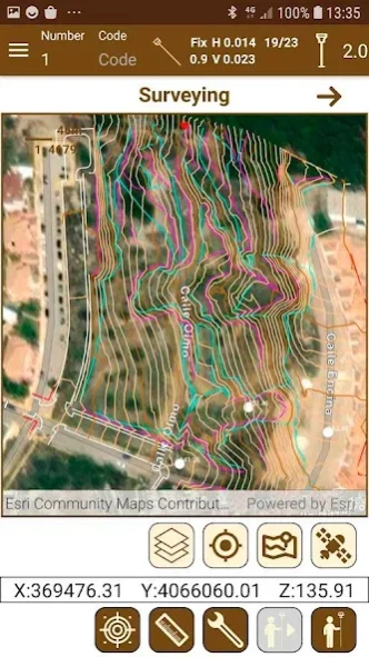
ESRI TM base maps with worldwide coverage are used, which can be viewed in street, satellite or topographic mode. You can also upload files in DXF, DWG, GML, KML, KMZ and shape formats, both local and in the cloud and add web map services (WMS).
The program includes the EPSG database of geodetic systems, being able to work with different coordinate reference systems organized by countries, and local systems can also be defined.
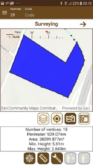
Surveying 🦺
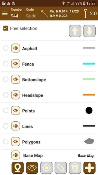
The application makes it very easy to survey topographic points and linear and polygonal entities, which are drawn in layers and with customized symbology. The continuous mode allows you to record points automatically, specifying a distance, time or slope interval.
TcpGPS controls at all times the type of position, horizontal and vertical accuracies, number of satellites, real time age, etc. and warns if any of the indicators is out of tolerance. It is also possible to set a minimum observation time and work with epochs.
Photographs, voice notes and optional codes can be associated to the objects, as well as user-defined attributes, ideal for GIS projects.
All collected data can be exported to multiple formats and shared from within the application, to be stored in the cloud or sent by email or other means.
Stakeout 📍
Points, lines and polylines of the cartography can be staked out, designating them graphically or selecting them by various criteria. The application offers different help modes, such as map, compass, target and augmented reality. Voice prompts or sounds can also be activated.
GNSS receivers 📡
The software allows you to easily connect to any NMEA-compliant receiver. In addition, you can configure various receivers integrated in the device or connected via Bluetooth, to work in base, rover or static mode and use corrections via radio or Internet with data from the collector or the equipment itself.
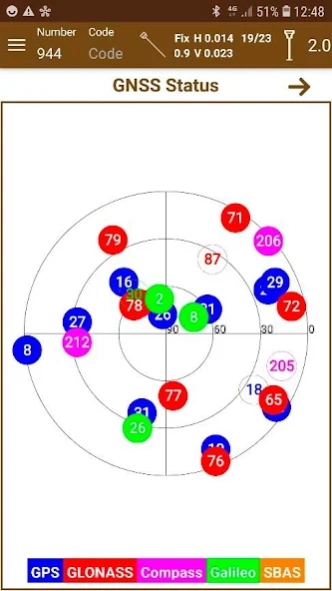
The status bar shows at all times the position type, accuracies, IMU status, etc. and supports GPS, GLONASS, BeiDou, Galileo and SBAS constellations.
Professional Version
Ambitious projects need tools that are at the cutting edge of technology to maximize productivity and achieve success.
The professional version of TcpGPS is very useful for working on road, railroad and linear projects in general, being able to import LandXML files and other formats. It is possible to stake out points with respect to the alignment, or specific vertices such as road edge, shoulder, curb, pavement footing... Specific options for slope control are also available.
The program generates the digital terrain model and contour lines from optional points and break lines. It is also possible to compare the current elevation with that of a reference surface.
About TcpGPS - Surveying with GNSS
TcpGPS - Surveying with GNSS is a free app for Android published in the System Maintenance list of apps, part of System Utilities.
The company that develops TcpGPS - Surveying with GNSS is Aplitop - Surveying & Civil Engineering Solutions. The latest version released by its developer is 2.7.1.2.
To install TcpGPS - Surveying with GNSS on your Android device, just click the green Continue To App button above to start the installation process. The app is listed on our website since 2024-04-01 and was downloaded 2 times. We have already checked if the download link is safe, however for your own protection we recommend that you scan the downloaded app with your antivirus. Your antivirus may detect the TcpGPS - Surveying with GNSS as malware as malware if the download link to com.aplitop.tcpgps is broken.
How to install TcpGPS - Surveying with GNSS on your Android device:
- Click on the Continue To App button on our website. This will redirect you to Google Play.
- Once the TcpGPS - Surveying with GNSS is shown in the Google Play listing of your Android device, you can start its download and installation. Tap on the Install button located below the search bar and to the right of the app icon.
- A pop-up window with the permissions required by TcpGPS - Surveying with GNSS will be shown. Click on Accept to continue the process.
- TcpGPS - Surveying with GNSS will be downloaded onto your device, displaying a progress. Once the download completes, the installation will start and you'll get a notification after the installation is finished.
